Wholly Owned Uranium Projects

Overview

Cosa Resources’ 100% owned* uranium land package comprises over 220,000 ha across multiple projects in the Athabasca Basin region, the world’s most prolific district for high-grade uranium discoveries. Many of Cosa’s projects are underexplored or virtually untouched by modern exploration and offer significant upside potential through discovery of the next tier-1 uranium deposit.

Figure A – Cosa Resources Uranium Exploration Properties

Ursa

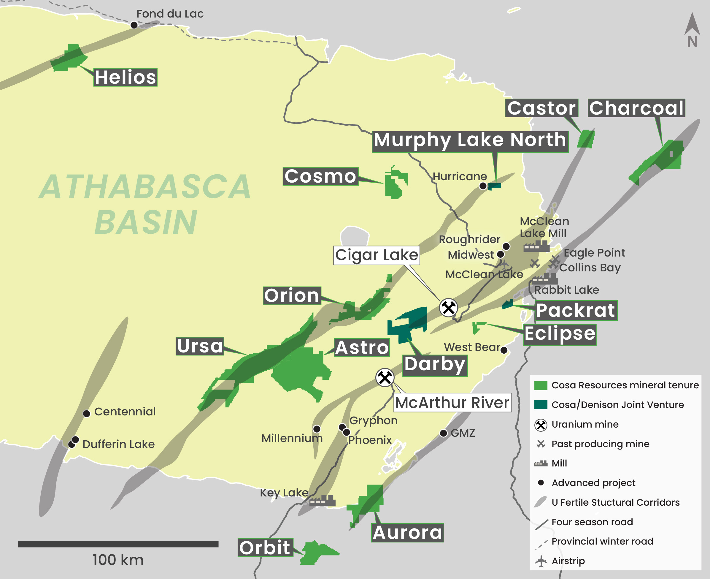
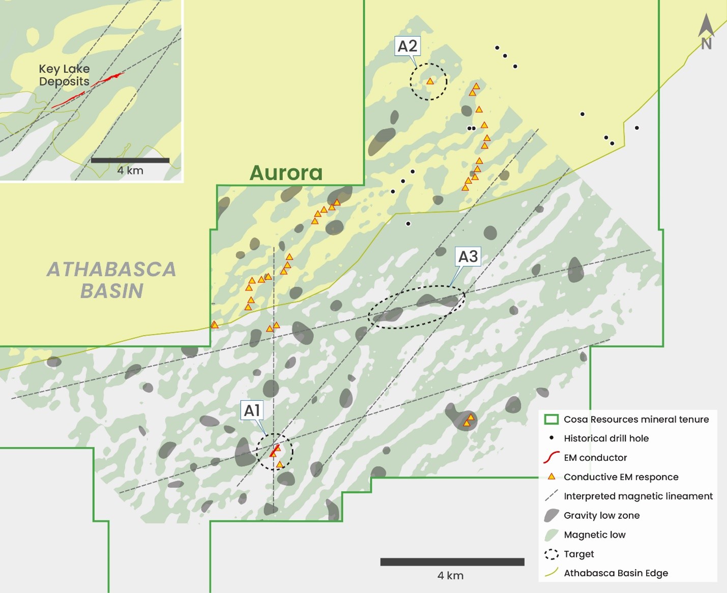
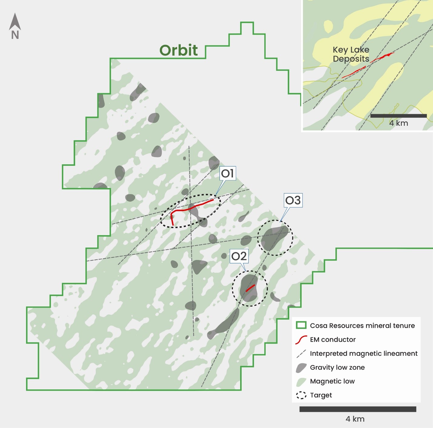
Located 45 kilometres west of the McArthur River mine and over 60,000 hectares in size, Ursa captures more than 60 kilometres strike length of the Cable Bay Shear Zone, a structural corridor with several known uranium occurrences and potentially the last remaining eastern Athabasca corridor to have not yet yielded a major uranium discovery.

Drilling during Cosa’s recent summer campaign successfully identified a new zone of basement-hosted radioactivity within a broader interval of hydrothermal alteration in the basement and lower sandstone. The Company believes that the work completed to date, including deployment of Ambient Noise Tomography (ANT) over much of the Kodiak trend, has significantly upgraded the project by identifying several anomalies that are similar to what was targeted where the company intersected radioactivity. With no drilling within roughly two kilometres of the radioactive intercept, Cosa’s technical team is eager to return to Ursa for follow up work.

Figure A – Ursa Property

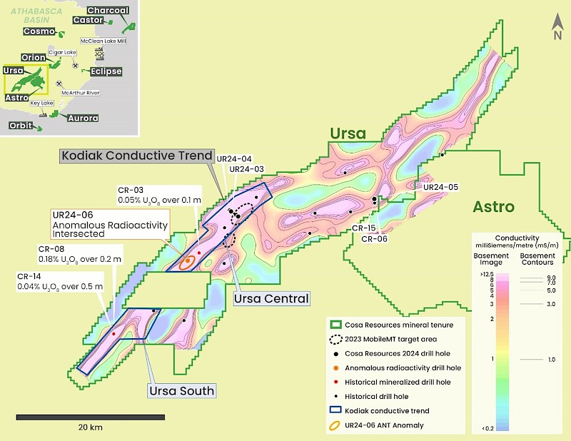
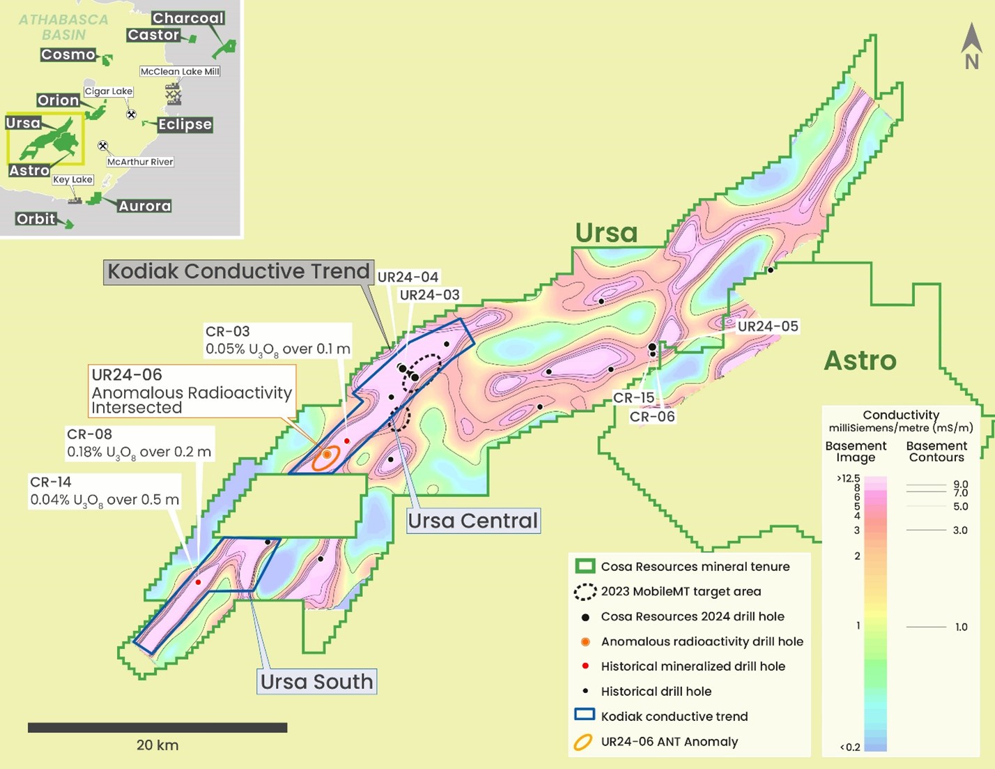
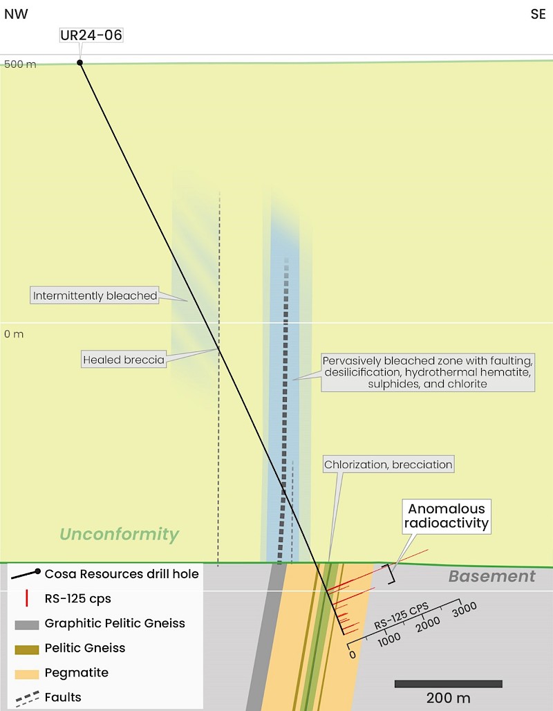
Drill hole UR24-06 pictured below was the first drill hole to test only an initial ANT target area during the recent summer drill program. The drill hole intersected a broad zone of unconformity-model type sandstone structure and alteration near the unconformity which may represent a very compelling follow up drill target pending receipt of uranium assay.

Drill hole UR24-04, pictured, below, targeted the down dip extension of sandstone hosted structure, alteration, and uranium geochemistry intersected by drill hole UR24-03. UR24-04 undershot the optimum target by approximately 50-metres however the drill hole successfully intersected a significant basement conductor at depth characterized by decimetre- to metre-scale zones of sub massive graphite mineralization, a critical indicator of structural displacement and hydrothermal activity within the Athabasca Basin.

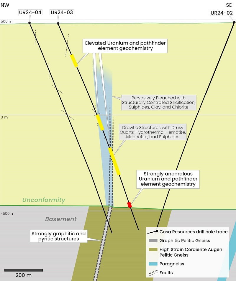
The combined results of UR24-04 and UR24-06, spaced roughly nine kilometres apart, demonstrate that the Kodiak trend appears to have all of the necessary ingredients to form a major unconformity style uranium deposit, and the Company believes that this drill program has significantly advanced the Ursa project as a whole.

Orion

Orion is located 29 kilometres west of the Cigar Lake uranium mine and immediately east of Orano’s Parker Lake Project. The Project covers approximately 25 kilometres of strike length of the interpreted extension of the Larocque Lake Trend. Cosa has repeatedly expanded its 100%-owned, 20,255-hectare Orion Project since initial acquisition in 2022 as the fertile Larocque Lake Trend hosts numerous occurrences of high-grade mineralization to the northeast while the portion covered by Orion is highly underexplored.

Orion is on the interpreted western extension of the Cigar Lake – Tucker Lake trend where it intersects the Larocque Lake trend (Figure 3). Drilling on trend at Parker Lake has intersected broad zones of structural disruption in the sandstone with illitic hydrothermal alteration and anomalous uranium geochemistry, including 0.05% U3O8 over 1.0 metres (932.4-933.4 metres) immediately above the unconformity in drill hole PAR-03. Basement intersections included graphitic lithologies and structures, indicating basement geology and sandstone alteration along trend is consistent with deposits in the region.

In 2023, MobileMT™ surveying completed by Cosa over the western portion of Orion identified basement hosted conductive zones overlain by conductivity anomalies in the sandstone. Follow up ANT surveying in 2024 identified several kilometre-scale and vertically extensive low velocity anomalies which are interpreted to reflect prospective structures and/or alteration above conductive basement zones and are considered high priority targets for additional follow up (see Cosa’s News Release dated 28 May 2025).

Figure A – Orion Property


Aurora

The Aurora Project covers a 17-kilometre section of the southeastern rim of the Athabasca Basin located 16 kilometres east of Key Lake and 40 kilometres south of the GMZ. Sandstone cover is expected to be less than 100 metres thick in the northern third of Aurora and absent in the remainder. Aurora was last drilled in 1979 and ground work since 1989 is limited to surficial sampling and prospecting. Historical drill logs suggest the presence of favourable structure and alteration.

Three initial follow-up target areas were identified by VTEM and gravity surveying at Aurora. The A1 target area is the highest priority and characterized as a bedrock-hosted conductive feature trending 045 degrees proximal to interpreted magnetic lineaments at orientations similar to Key Lake (045 and 065 degrees) and the GMZ (north-south). The A2 target area is a single-line conductive response interpreted to be basement-hosted. The A3 target area is a trend of gravity low zones along a prominent, 065-degree trending magnetic lineament. Similar to Key Lake, the A3 area is bracketed by 045-degree trending magnetic lineaments.

Numerous other conductive responses were identified, which are not definitively derived from basement rocks, several of which are coincident with gravity low zones. Additional work is warranted to evaluate these features.

Figure A – Aurora Project

Orbit

The Orbit Project is located 19 kilometres south of the Athabasca Basin and 22 kilometres south of the Key Lake Mill and former Key Lake Min. The Key Lake Mine produced 209.8 million pounds of U3O8 at an average grade of 2.3% U3O8 from deposits situated along a 065-degree trending conductive corridor with associated 045-degree trends. The Key Lake Mill processes ore from the McArthur River Mine. Provincial Highway 914 passes within 17 kilometres of Orbit.

Three initial target areas were identified at Orbit from the airborne VTEM and gravity survey results. Target area O1 is considered the highest priority and features a 1.6-kilometre-long EM conductor with coincident gravity lows located on the northern flank of a magnetic high. Similar to Key Lake geology, the O1 conductor is oriented at 065 degrees. An interpreted north-south oriented magnetic lineament crosscuts the center of the O1 conductor and is coincident with a gravity low, similar to the GMZ discovered in 2021. A second gravity low anomaly is present on the western end of the O1 conductor coincident with a flexure to the south and is crosscut by an 065-degree trending magnetic break.

The O2 target area is a bedrock conductivity anomaly with an enveloping gravity low. The O3 target area is at the intersection of interpreted 045- and 065-degree trending magnetic lineaments and contains the strongest gravity low zone identified at Orbit.

Figure A – Orbit Property

Cosmo

Cosmo comprises 12 claims totaling 9,308 hectares in the eastern Athabasca Basin and is located 36 kilometres west of the Hurricane Deposit and 58 kilometres north of the Cigar Lake Mine. Provincial Highway 905 passes within seven kilometres of the Property and a network of trails and a provincial powerline pass through the Property.

Cosmo covers 18 kilometres of curvilinear magnetic low strike length interpreted to represent favourable metasediments. Historical exploration was limited to a 1979 lake sediment sampling program and a 2007 airborne geophysical survey. While no drilling is known within the Property, historical drilling located 13 to 25 kilometres along strike to the east intersected several intervals of weak uranium mineralization, including 0.20% U3O8 over 1.2 metres in drill hole BL-14-20 (549.9 – 551.1 m).

Disclaimer

The scientific and technical information in this website has been prepared in accordance with the Canadian regulatory requirements set out in National Instrument 43-101 (Standards of Disclosure for Mineral Projects) and reviewed and approved by Andy Carmichael, P.Geo., Vice President, Exploration for Cosa Resources. Mr. Carmichael is a Qualified Person as defined under the terms of National Instrument 43-101. This website refers to neighboring properties in which the Company has no interest. Mineralization on those neighboring properties does not necessarily indicate mineralization on the Company’s properties. Some Project descriptions refer to historical drill hole logs both off- and on-property. Cosa considers this information to be relevant to exploration, however these results have not been physically verified by Cosa’s Qualified Person.