Winter 2026 Drill Program
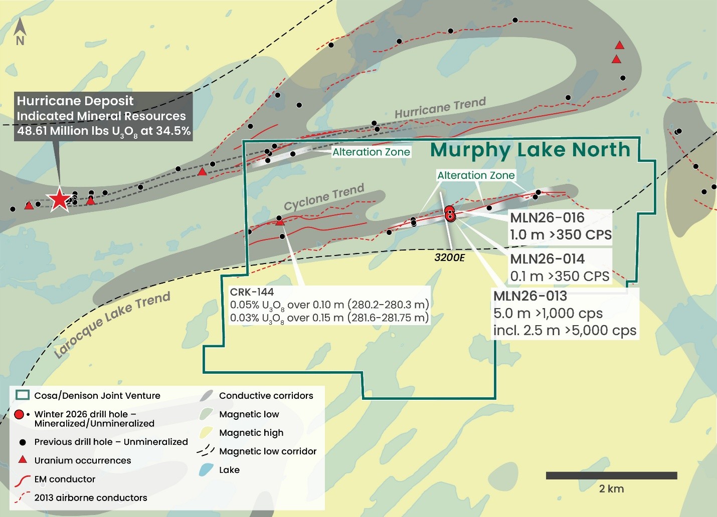
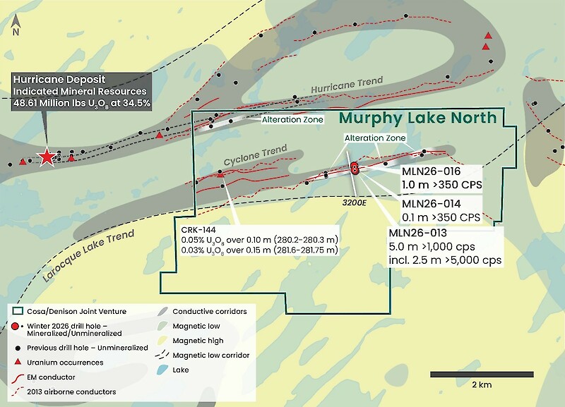
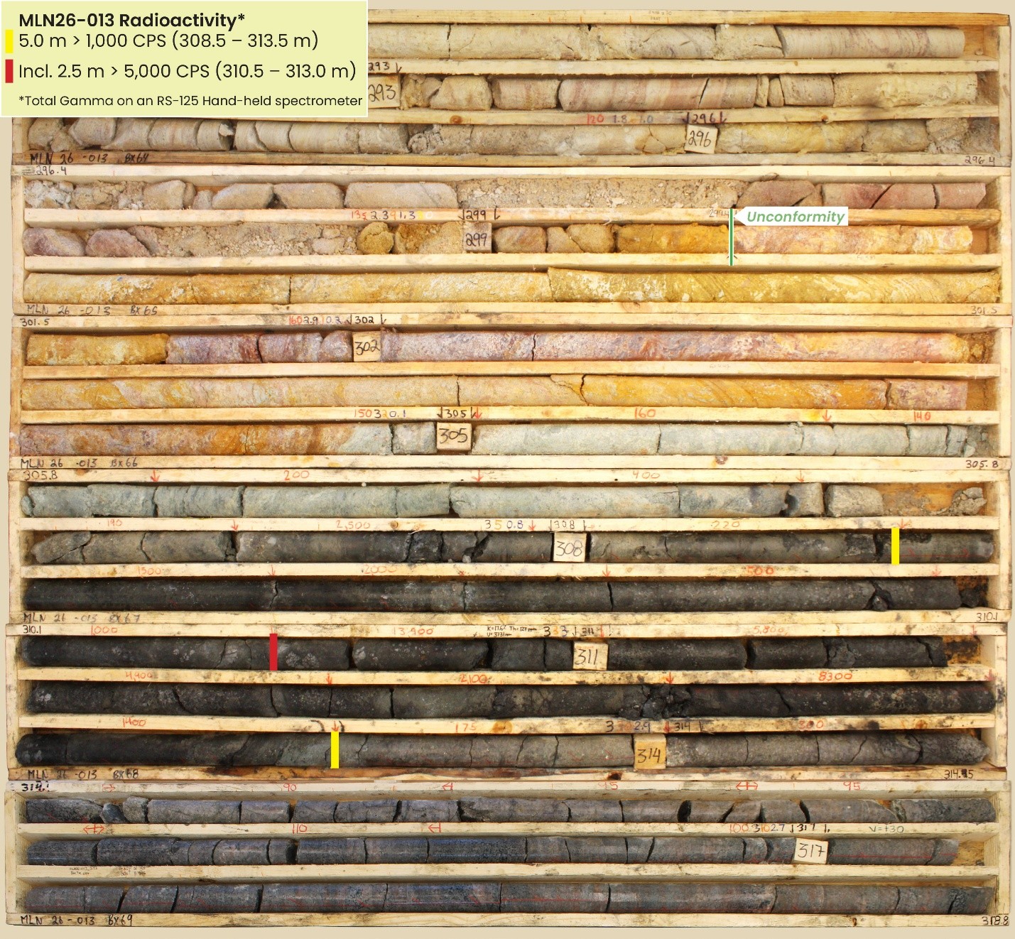
Winter drilling at MLN followed up structure and alteration intersected at the Cyclone trend in summer 2025. Five drill holes totaling 2,015 metres were completed during the program with three drill holes intersecting anomalous radioactivity1. The first drill hole of the program, MLN26-013, intersected the strongest radioactivity including a 5.0 metre interval of continuously anomalous radioactivity in the upper basement (see Cosa’s news release dated March 24, 2026). Two holes were completed to directly follow up radioactivity in MLN26-013. Two additional holes were completed to define underlying geology ahead of summer drilling and follow up another radioactive intersection. All drill holes were completed on Section 3200E.
Three of five drill holes intersected anomalous radioactivity (Table 1) in two discrete zones. Drilling also defined highly prospective geology with similarities to the Hurricane deposit and other unconformity related uranium deposits of the eastern Athabasca Basin.
Hole
ID |
From
(m) |
To
(m) |
Length
(m) |
Radioactivity
(CPS)1, 2 |
Orientation
(Azi./Dip) |
Location |
| MLN26-0133 |
306.5 |
307.0 |
0.5 |
>350 |
166 / -60 |
Section 3200E |
| and |
307.5 |
308.0 |
0.5 |
>1,000 |
|
| and |
308.5 |
313.5 |
5.0 |
>1,000 |
|
|
| incl. |
310.5 |
313.0 |
2.5 |
>5,000 |
|
| incl. |
310.5 |
311.0 |
0.5 |
>13,000 |
|
| MLN26-014 |
278.5 |
278.6 |
0.1 |
>350 |
170 / -75 |
Section 3200E |
| MLN25-015 |
No significant radioactivity |
000 / -90 |
Section 3200E |
| MLN26-016 |
286.5 |
287.5 |
1.0 |
>350 |
165 / -65 |
Section 3200E |
| MLN26-017 |
No significant radioactivity |
000 / -90 |
Section 3200E |
- Radioactivity is total gamma from drill core measured with an RS-125 hand-held spectrometer
- Measurements of total gamma on drill core are an indication of uranium content but may not correlate with chemical assays
- Previously released
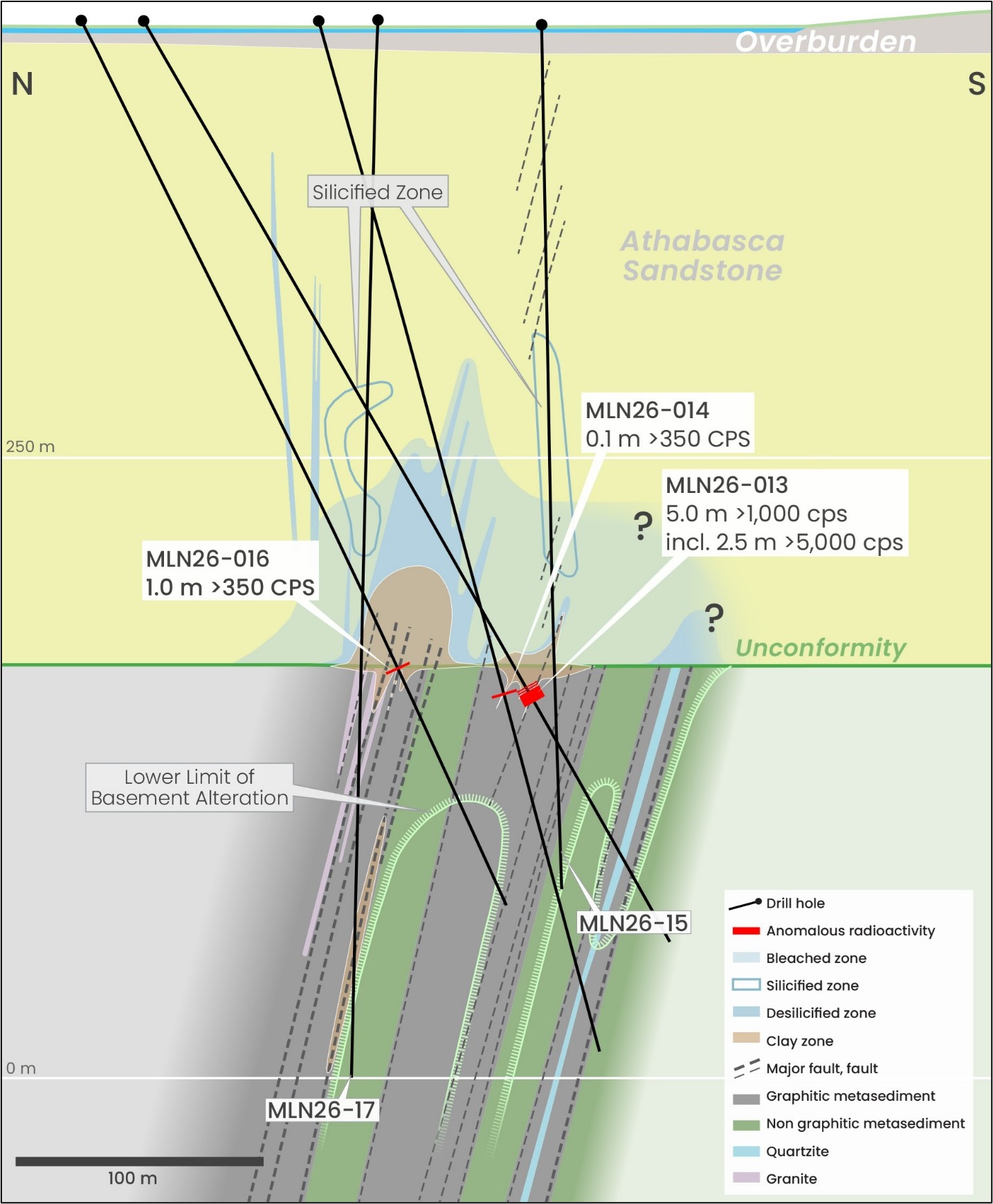
Multiple intervals of anomalous radioactivity were intersected in two discrete zones (Table 1, Figure 3). All radioactive intersections are associated with faulting and broad zones of strong hydrothermal alteration in the sandstone and basement. All radioactive intersections remain open along strike to the east and west for at least 600 metres and some intersections remain open on section.
MLN26-013, the first hole of the winter program, intersected a significant zone of structure and alteration underlain by faulted graphitic gneiss hosting several intervals of anomalous radioactivity between 306.5 and 313.5 metres ranging from 400 to 13,900 cps.
Radioactivity in MLN26-013 was followed up to the north (MLN26-014) and south (MLN26-015). MLN26-014 intersected anomalous radioactivity in the upper basement within a 0.5 metre strongly altered interval. Elevated radioactivity was intersected in the lower sandstone by MLN26-015.
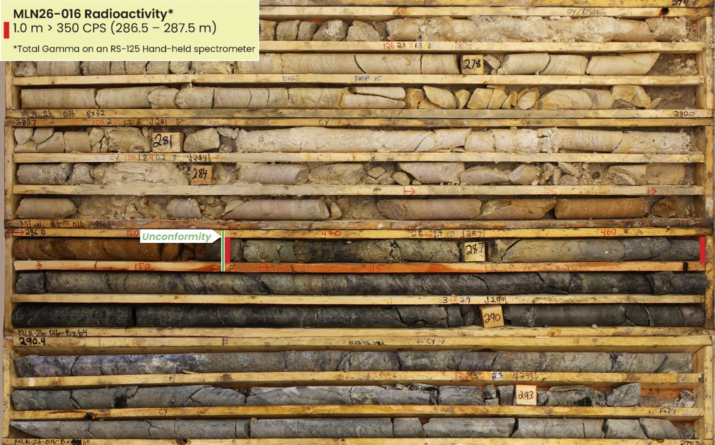
50 metres north of MLN26-013, MLN26-016 intersected a 1.0 metre interval of anomalous radioactivity immediately below the unconformity associated with a broad zone of strong alteration and structure.
Cyclone 3200E Geology
Drilling determined the Cyclone trend is underlain by a package of graphitic and non-graphitic pelitic gneisses and quartzite over 100 metres in width. The full width of the mineralized structural corridor is unknown as additional prospective graphitic rocks may lie north and south of current drilling.
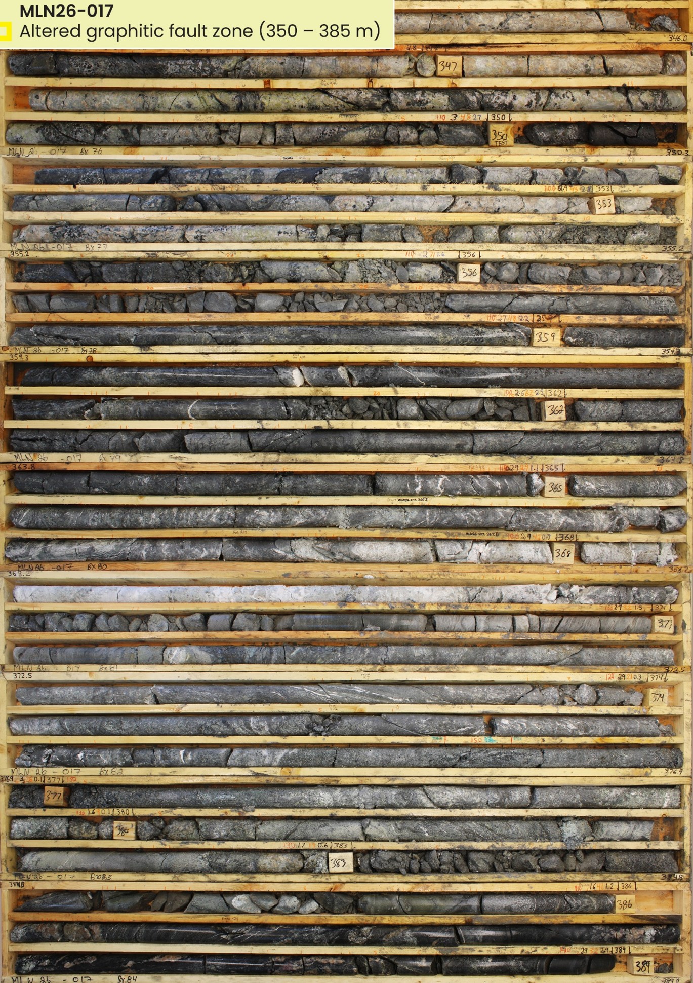
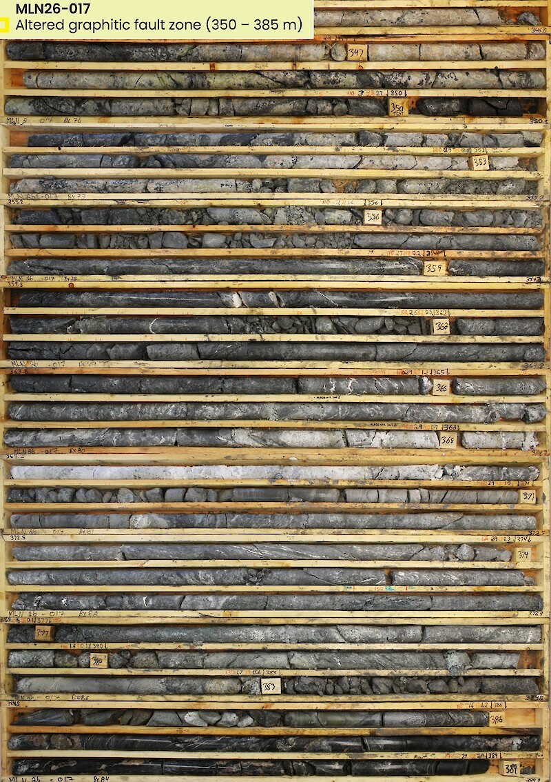
Graphitic basement units host faulting and alteration. Basement faulting is best developed in the northernmost graphitic unit where MLN26-016 and -017 intersected metre- to decametre-scale fault zones, including a 35 metre interval that is enveloped by moderate to strong alteration (Figure 6). At the unconformity, the northern edge of this fault zone hosts radioactivity (MLN26-016) which remains open in several directions. 100 metres to the south, MLN26-013 and -014 intersected another graphitic fault zone which is enveloped by alteration and remains untested at the unconformity.
Significant zones of sandstone structure and alteration are present throughout, and sandstone alteration patterns are similar to the Hurricane deposit where widespread bleached zones and distal silicified zones envelop broad desilicified zones cored by clay alteration (Figure 3). MLN26-013, -014, and -016 all intersected decametre-scale zones of sandstone faulting and alteration overlying the northern graphitic fault zone (Figure 3). Zones of faulting and alteration in the upper to middle sandstones of MLN26-013 and -016 suggest additional potential north of existing drilling.
Multiple altered basement fault zones remain untested at the unconformity and down-dip.

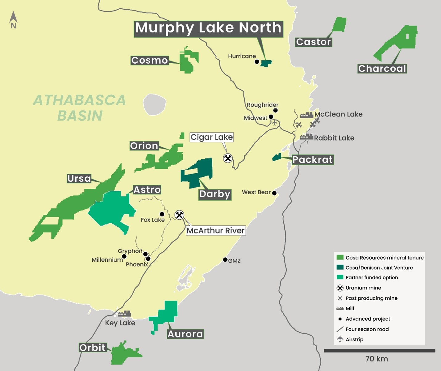
MLN covers a portion of the Larocque Lake trend and is located 2.7 kilometres east of the Hurricane deposit (Figures 1 and 2). Hurricane is the world’s highest-grade indicated uranium resource and was discovered and delineated for IsoEnergy Ltd. by current members of Cosa’s team. The Larocque Lake trend also hosts the high-grade Larocque Lake Zone, Yelka Prospect, and Alligator Lake Zone. MLN contains the along-strike extension of basement geology underlying the Hurricane deposit (the Hurricane trend), as well as a parallel conductive trend to the south (the Cyclone trend). Cosa’s winter 2026 drill program intersected several meters of basement hosted radioactivity within a broader zone of strong structure and alteration at the Cyclone trend. Following up these results is the primary objective for the remainder of 2026 at MLN.