Denison Mines Strategic Collaboration

Joint Venture Overview

In January 2025, Cosa entered a transformative strategic collaboration with Denison Mines that has secured Cosa access into several additional highly prospective eastern Athabasca uranium exploration projects. These Projects offer Cosa over 20,000 ha of additional exposure into what the Company considers to be mature, discovery-ready projects that are well situated close to existing eastern Athabasca infrastructure and boast several walk-up drill targets based on encouraging results from historical drilling. Most notable is the Murphy Lake North project with is on trend and within four kilometres of IsoEnergy’s Hurricane Deposit which was discovered in 2018 by Cosa’s management and currently holds the title as the world’s highest grade indicated resource in uranium. As Cosa’s largest shareholder, Denison Mines gains exposure to Cosa’s potential for exploration success and its pipeline of uranium deposits.

Murphy Lake North

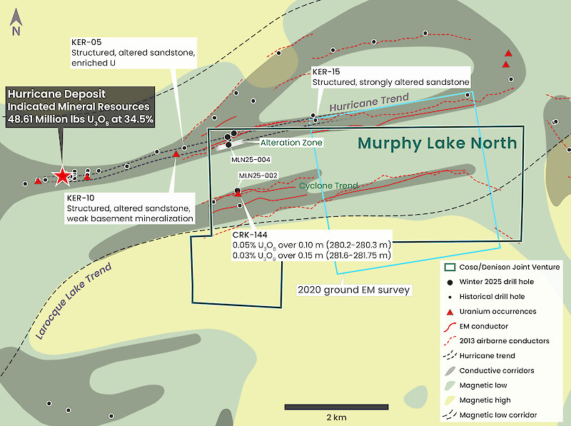
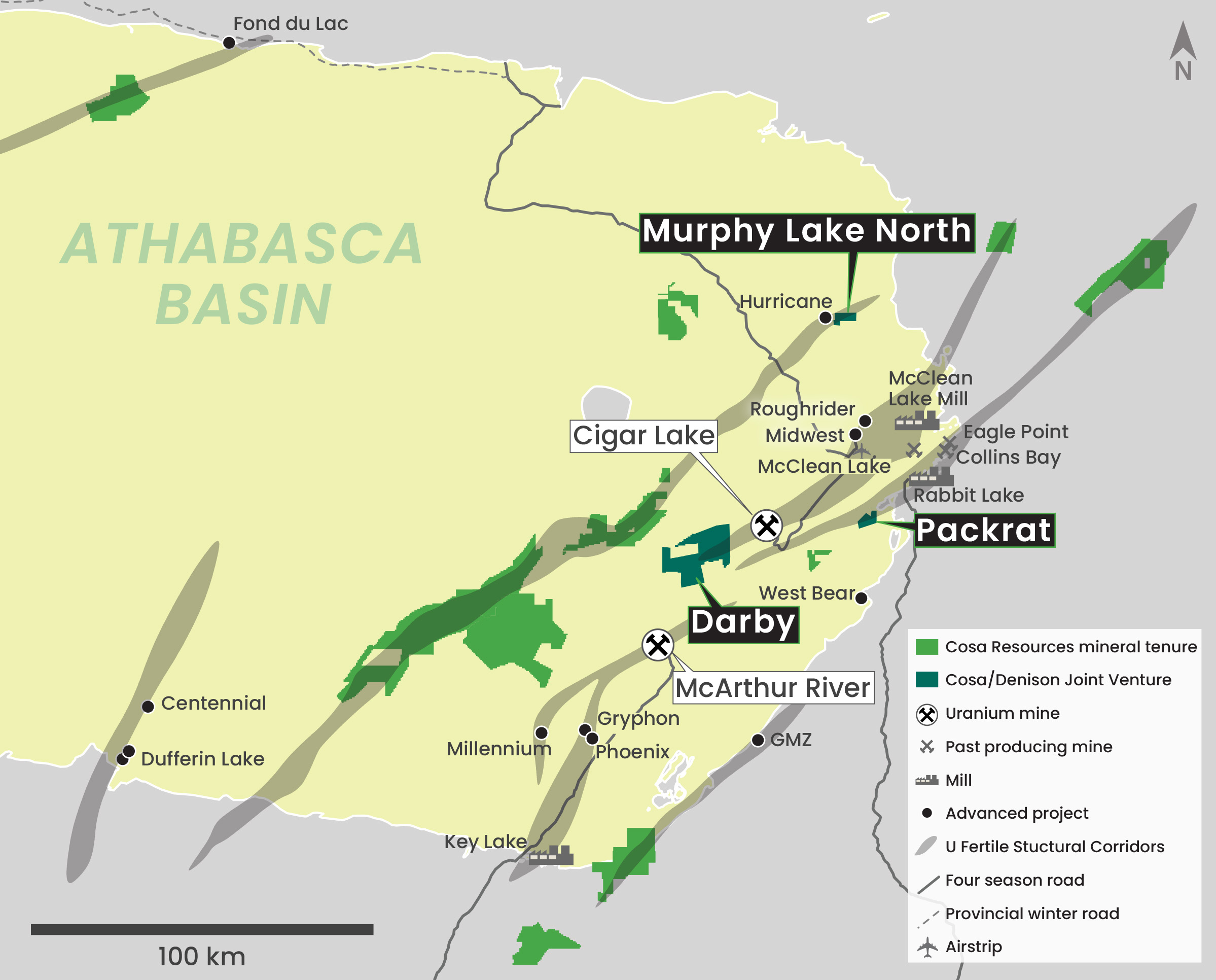
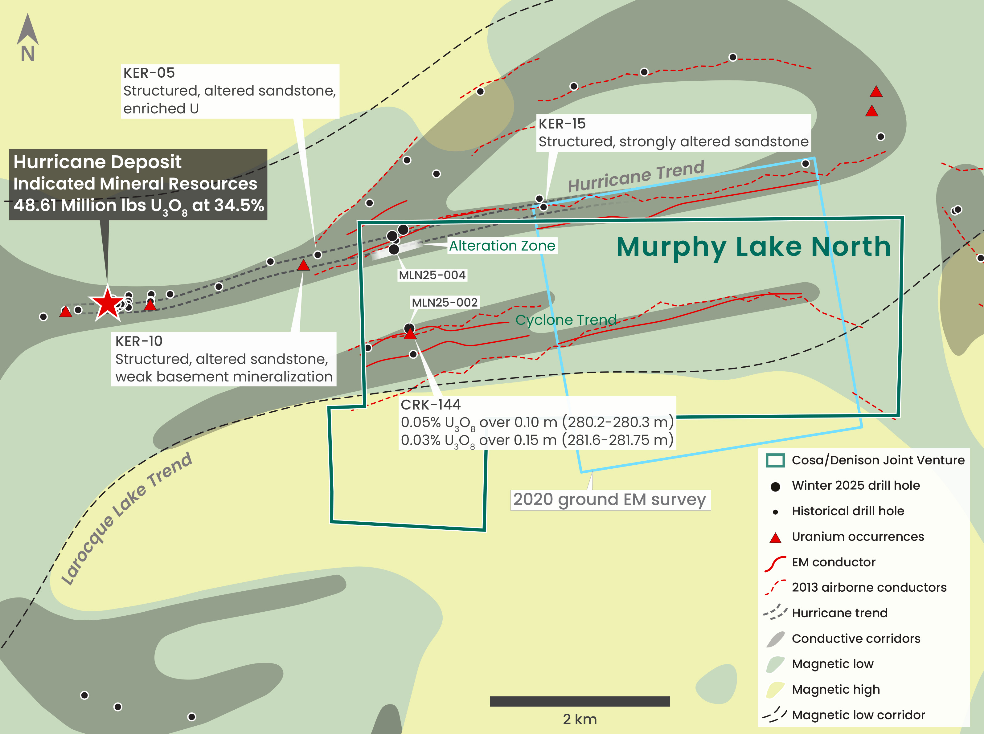
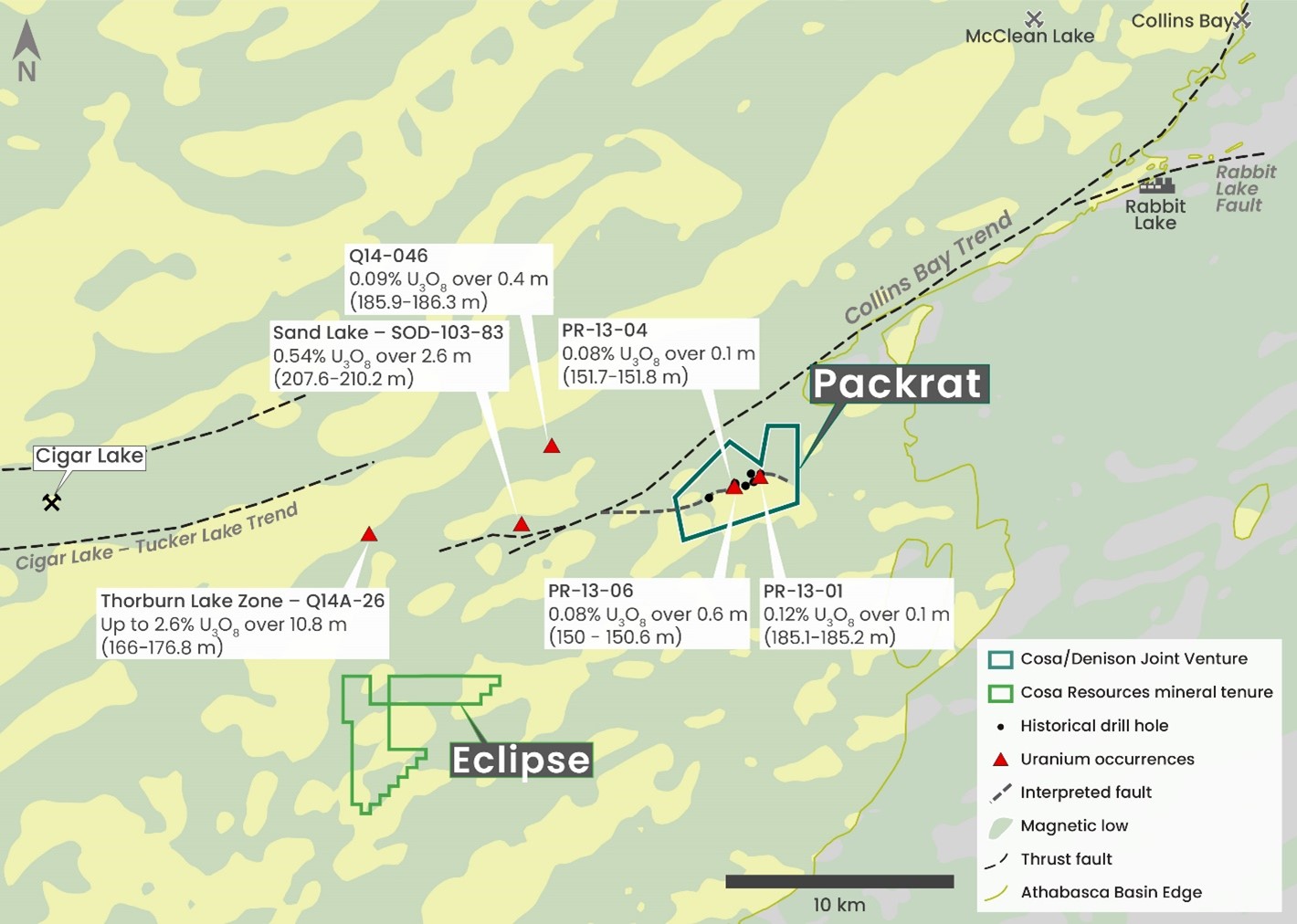
Murphy Lake North covers a portion of the Larocque Lake trend and is located 2.7 kilometres east of the Hurricane deposit. Hurricane is the world’s highest-grade Indicated Uranium Resource and was discovered and delineated for IsoEnergy Ltd. by current members of Cosa’s management, board of directors, and advisors from 2018 through 2022. The Larocque Lake trend also hosts the high-grade Larocque Lake Zone, Yelka Prospect, and Alligator Lake Zone.

Initial drilling in winter 2025 confirmed that up to two kilometres of Hurricane trend basement geology is present within the Project (See Cosa news release dated March 20, 2025). While testing the southern portion of the Hurricane trend, the fourth and final drill hole of the program intersected a broad zone of alteration and structure in the lower sandstone that is open along strike in both directions. The depth to the unconformity at Murphy Lake North is approximately 250 metres.

Per the Company’s news release dated 17 June 2025, an expanded summer drill program is set to commence in July 2025.

The summer drill program is planned to comprise over 3,000 metres of drilling at the Hurricane and Cyclone trends. Drilling is anticipated to start at the Hurricane trend with the balance of budgeted meters to be completed where results justify.

Hurricane Trend

Summer drilling is planned to follow up the zone of sandstone alteration and structure intersected by the fourth and final drill hole of the winter exploration program, MLN25-004. Follow up is expected to involve a series of step outs along strike to determine if the alteration hosts uranium mineralization.

Cyclone Trend

The mineralized Cyclone trend is located south of and oriented sub-parallel to the Hurricane trend. Since 1996, a series of historical airborne and ground electromagnetic (EM) surveys at MLN mapped several discrete conductors within the broader Cyclone trend. Conductivity at Cyclone is best defined in the central portion of MLN where 2020 EM surveying completed by Denison mapped a basement EM conductor coincident with a conductive trend identified by 2013 airborne surveying. Summer drilling is planned to evaluate Cyclone at wide spacing for prospective structure and/or alteration.

Darby

The Darby Project is a 70/30 Cosa/Denison Joint Venture operated by Cosa. Located 10 kilometres west of the Cigar Lake Mine, Darby is interpreted to contain more than 25 kilometres of prospective conductive strike length. Cosa’s reinterpretation of historical data has flagged the 95B, 96D, and 4A conductive trends as initial high-priority exploration targets within the Darby Project. Historical drilling on 95B defined more than 25 metres of unconformity topography where a package of metasedimentary rocks hosting graphitic brittle structure, hydrothermal alteration, and weak uranium mineralization lies in fault contact with underlying granitic rocks. Only one drill hole completed along strike is interpreted to have intersected the optimal target in this prospective geological setting. Weak uranium mineralization has also been intersected in the northeast portion of Darby proximal to the Cigar Lake – Tucker Lake trend, and along the northern extension of the 4A trend north of Darby. The depth to the unconformity at Darby is between 480 and 650 metres.

Cosa plans to begin the summer exploration season by relogging historical drill core from Darby to confirm its interpretations and refine drill-ready targets in advance of an initial drilling program under development for the winter of 2026.

Packrat

The Packrat Project is located 28 kilometres east of the Cigar Lake Mine and 19 kilometres southwest of the Rabbit Lake Mill (Figure 4). Packrat covers a prominent magnetic break and basement-hosted resistivity low trend lying along interpreted magnetic lineaments related to the Cigar Lake – Tucker Lake magnetic low trend. Limited historical drilling on Packrat which targeted the resistivity low trend and magnetic break intersected weak uranium mineralization and zones of structural disruption and alteration of basement rocks. Initial work at Packrat is expected to include compilation and reinterpretation of historical geophysical and drilling data.

The depth to the unconformity at Packrat is less than 100 metres.