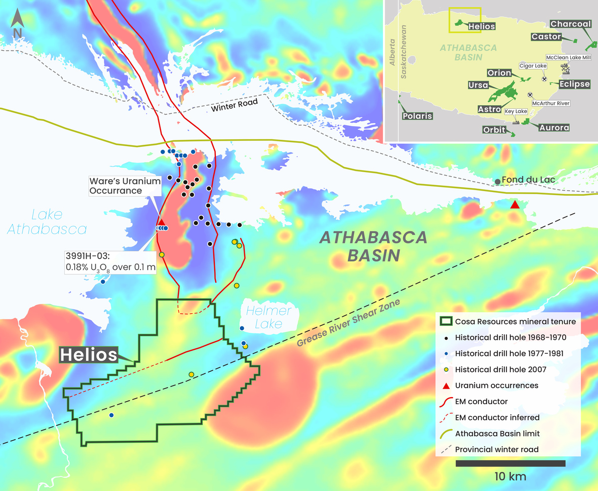
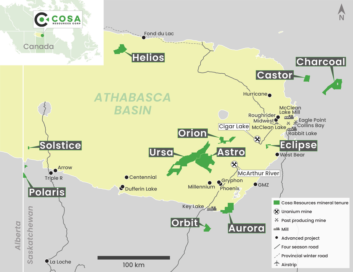
Athabasca Uranium Projects

Overview

Cosa Resources' 100% owned* uranium land package consists of more than 87,800ha, all located in the Eastern Athabasca Basin, the heart of the Canadian uranium mining sector (Figure 1).

Figure 1 – Cosa Resources Uranium Exploration Properties

Cosa's portfolio is strategically located, with all four properties occurring within prospective northeast trending uranium corridors (Figure 2). Long linear northeast trends with low magnetic susceptibility in the Eastern Athabasca Basin have hosted some of the largest uranium deposits ever discovered including Cameco's McArthur River mine. The Ursa property covers a large portion of the underexplored Cable Bay Shear Zone uranium corridor.

Figure 2 – Cosa Resources Uranium Exploration Properties

Ursa

Ursa is a large, 57,000ha property located approximately 45km west of Cameco Corp.'s McArthur River uranium mine (Figure 3). The Property covers more than 60km of strike length of the Cable Bay Shear Zone, a structural corridor (Figure 2) with known uranium occurrences. The vast majority of the strike length remains completely untested. Anomalous uranium and uranium pathfinder elements have been intersected in the few areas evaluated by historical drilling (Figure 3). For example, historical drill hole CR-8 intersected 0.2% U3O8 over 0.2m and was never adequately followed up. The depth to the sub-Athabasca unconformity is expected to range between 600m and 975m at Ursa.

Given the presence of geophysically conductive trends, structurally disrupted sandstone and basement units, and elevated uranium, the Cable Bay Shear Zone offers a highly prospective, significantly underexplored analogy to these better-known uranium corridors, as displayed in Figure 2.

Figure 3 – Ursa Property

*Approximately 3,470 ha of claims on Ursa are subject to a 2.0% NSR, of which Cosa has the right to purchase 1.0% (one-half) of the NSR for $1.0 million in cash.

Orion

The Orion property is located approximately 34km northwest of the McArthur River uranium mine and is an interpreted extension of Larocque uranium corridor and a splay off the Cable Bay Shear Zone (Figure 4). The property is characterized by a north-south zone of low magnetic susceptibility with historical electromagnetic conductors that wraps around to the east at its north end, implying prospective structural complexity. The mag low zone running the entirety of the property is an interpreted 'structural bend' of graphitic metasediments wrapping around a granitic dome. This structural and geological setting is considered prospective for uranium. The property has never been drilled. Nearby historical drill holes suggest the depth to the sub-Athabasca unconformity is 750m to 900m.

Figure 4 – Ursa & Orion Properties

Charcoal

A large, 21,080ha property, Charcoal is located 52km northeast of Cameco Corp.’s Rabbit Lake – Eagle Point mine operations. The property sits within a prominent magnetic low anomaly that extends northeast from the mine (Figure 5). The magnetic low signature likely indicates the presence of prospective metasedimentary bedrock beneath the glacial till cover. Additionally, historical assessment records from the Government of Saskatchewan indicate the presence of numerous airborne electromagnetic conductors, possibly indicating the presence of graphitic metasediments and associated brittle faults, which are often associated with uranium mineralization in the Athabasca Basin. The property is 8km up-ice from a historical radioactive boulder field. As Charcoal is beyond the basin edge, basement rocks extend to the top of the bedrock and there is no overlying sandstone.

Castor

Castor, like Charcoal, lies beyond the Athabasca Basin edge and therefore has no overlying sandstone cover. The property is located 55km north of Cameco Corp.’s Rabbit Lake – Eagle Point uranium mine operations (Figure 5). Basement rocks extend to the top of the bedrock. Castor is located at the intersection of a prominent northeast trending magnetic low anomaly that is roughly parallel to the Eagle Point – Collins Bay magnetic low at Charcoal and an east-west trending magnetic low anomaly. This intersection may be an area of enhanced structural complexity that would be prospective for uranium mineralization.

Current Exploration

On November 15th, 2022, it was announced that Geotech Airborne Geophysical Surveys (Geotech Ltd.) had been contracted to fly a 1,540 line-km of Versatile Time-Domain Electromagnetic (VTEM™ Plus) and Horizontal Magnetic Gradiometer survey over the Castor and Charcoal projects. Final results are expected in Q1 of 2023.

Figure 5 – Charcoal and Castor Properties

Disclaimer

The scientific and technical information in this website has been prepared in accordance with the Canadian regulatory requirements set out in National Instrument 43-101 (Standards of Disclosure for Mineral Projects) and reviewed and approved by Keith Bodnarchuk, Chief Executive Officer for Cosa Resources Corp. and a "qualified person" as defined by NI 43-101.